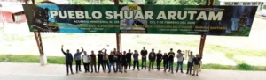
In the Amazon rainforests of Ecuador, a collaborative drone training workshop is empowering the Maikiuants, a Shuar Indigenous community, to better protect their ancestral territory. Supported by Conservation Allies, the University of Azuay GIS team in partnership with Ecoforensics provided ten indigenous paraecologists with hands-on training in drone operation and mapping.
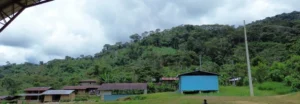
Held in southern Ecuador’s Morona Santiago province—where pressures from expanding gold mining concessions pose a growing threat to both people and biodiversity—the workshop focused on the legal and technical aspects of drone use. Participants received instruction on drone regulations, flight safety, and image collection before applying their skills in the field to capture photos and videos of their territory.
Drone technology offers an invaluable tool for indigenous communities like the Maikiuants to monitor land use, detect illegal encroachments, and document ecological changes. By creating detailed territorial maps, they can bolster land claims, plan patrol routes more effectively, and provide visual evidence to defend their forests in court. Undergraduate biology students from the University of Azuay, together with Lourdes Nunez, the Latin America Conservation Officer at Conservation Allies, also assisted with drone training and mapping work while gaining a deeper understanding of how indigenous knowledge and modern tools can align to protect the Amazon rainforests.
This initiative is part of a broader strategy to strengthen indigenous-led conservation by merging traditional stewardship with scientific and legal resources. It supports Ecuador’s progressive legal framework, which recognizes the rights of nature—an approach that allows ecosystems themselves to be represented in legal proceedings. By equipping communities with the tools to assert these rights, this partnership reinforces both the autonomy of Indigenous land defenders and the protection of critical Amazonian rainforest lands.